

Severe weather possible for central Alabama early Friday morning
March 4, 2023
A cold front moving through the state overnight Thursday and Friday morning is expected to bring high winds and possible tornadoes.
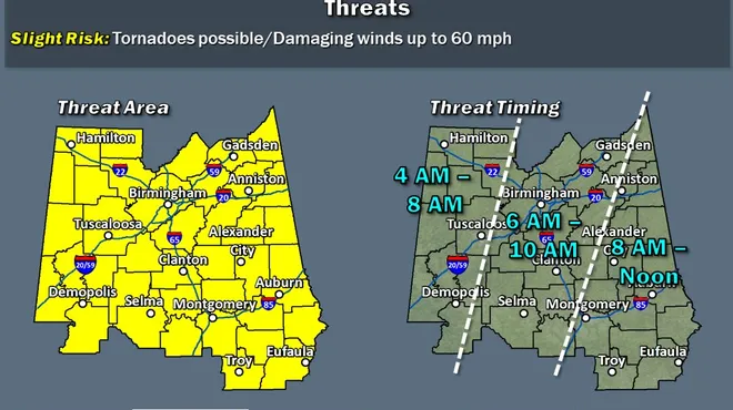
Central Alabama is under a “slight” risk of severe weather — that’s a two-out-of-five risk, with five being the highest category.
“Don’t look at the number, don’t look at colors on the map,” said Josh Johnson, chief meteorologist for WSFA. “There is going to be a risk of severe weather state-wide, most likely Friday morning. Don’t be afraid, but be aware.
“Right now this looks like a wind event, but there is the possibility for tornadoes to form.”
Timing is still up in the air, but the area of Demopolis to Tuscaloosa and west is expected to see the severe weather on Friday from 4 a.m. until 8 a.m. The Selma to Birmingham to Gadsden areas are under the gun from 6 a.m. until 10 a.m. on Friday, and Montgomery to Anniston and west are under threat from 8 a.m. until noon on Friday.
“Most people will be asleep when the weather starts to come through,” he said “You need to have a reliable source of information that can wake you up and keep you updated. And if you live in central Alabama or eastern Alabama, you still need that reliable source of information to keep you up to date.
“Rapidly changing weather conditions mean just that. There can be major changes in the forecast from 4 in the morning until noon.”It will stay windy Friday after the passage of the front. The good news is a stellar weekend forecast with plenty of sunshine and more seasonable temps. For those keeping score at home, the average lows for this time of year for the Montgomery area are in the mid 40s; the average highs are in the upper 60s.